Banshi R Saha

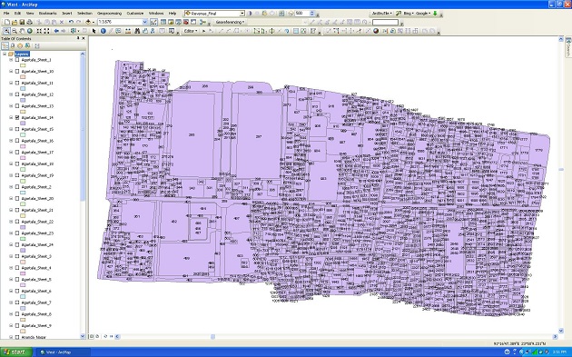
AGARTALA, January 30 (TIWN): Fallaciously being recognized as downtrodden and insurgent prone area to the people of the rest of India, the existence of erstwhile princely state Tripura as a part of union of India is not even known to people of many states. But that sort of ignorance has not obstructed Tripura State to develop an indigenous space application centre in the state on its own and the sci-fi Tripura has incidentally become a leader in the region.Tripura Space Application Centre (TSAC) has already become the first state in North East (NE) region to successfully complete the task of geo referencing of cadastral sheet. And it has been done for the entire state. And the same technological advancement and subsequently the achievement are limited in the entire country.While talking to this correspondent, the Principal Scientific Officer of TSCAC Nataraj Dutta, has informed, “All state space application centres are set up under the funding of Indian Space Research Organization (ISRO) and this is a chain of ISRO but ours one has fully been funded by the state government though the ISRO has consented to collaborate on the national projects, based on its requirements.†Scientific planning, sustainable development and making an optimum utilization of the available resources have been the priorities of the TSAC.
Besides, the groundwater mapping in the entire state has also been implemented by the centre, which is reported not to outsource any of its activities. “We lack proper manpower and including me only seven employees we do have and they are from our state Tripura and all of them are well experienced and equipped with all knowledge to take on any projects”, informed the in charge of TSAC. Furthermore, Geographical Information System (GIS) and Management Information System
To add to that, regarding the transmission lines from Palatana and Manarchak which are reported to carry power out of state, the TSAC is about to do the task of indentifying forest and non forest plots. “The entire state has a 0.6 meter resolution satellite imagery and 3Dimension (3D) imaging of the entire state has also been accomplished”, further added the TSAC official. On being asked about the use satellite maps and other global positioning system by the state security personnel for thwarting crime and spotting the movements of extremists, the TSAC top brass has said: “Yes they know that and they seem to use that.”
Besides, whatever projects are assigned by the state government TSAC does that and TSAC has its intention to develop its human resource through an active involvement of ISRO.
- 50-year-old Farmer Found Dead in a Pond in Golaghati
- Protest in Dharmanagar against Attack on CPI-M Rally
- ‘We Could Be Against Pakistan & Bangladesh but We Are Not Against Any Indian Party’ : Pradyot Debbarman said, as Astabal Rally Unfolded
- Dharmanagar Congress Bhawan attacked, set on Fire : Congress accused BJP: Many injured, Hospitalized
- ABVP MBB College President accused of Ragging ; Protested after Principal Summoned him
Special Articles
 Sanjay Majumder
 Anirban Mitra