TIWN

AGARTALA, April 13, 8 pm (TIWN): Tripura suddenly jolted with a high intensity earthquake on wednesday evening at 7.25pm. An earthquake of 6.9 intensity rocked India's northeastern states and adjoining Myanmar, Bangladesh and Bhutan.There were no immediate reports of casualties or damage to property."The quake, measuring 6.9 on the Richter Scale, occurred at 7.25pm and had its epicentre in Myanmar-India border region," said an official of the seismological centre at New Delhi.The earthquake was felt in parts of Manipur, Assam, Arunachal Pradesh, Meghalaya, Nagaland, Mizoram and Tripura . India's northeast is considered the sixth major earthquake-prone belt in the world. Guwahati and Agartala fall in what is called “very severe intensity zoneâ€, or zone V, the highest-risk earthquake zone. Latest Data from Global Seismic Monitor center at USA showing 6.9 richter scale magnitude earthquake took place 135 km below earth surface at Myanmar-India Border.Thousands of people ran towards road, open areas amid the chant of religious hyms as this severe earthquake shocked whole state and dampened the Bengali new year festivities.Guwahati, Shillong and Agartala are the three Northeast Indian cities at highest risk of being devastated by an earthquake, with 36 other cities in areas prone to earthquakes, according to government data.
The tremor occurred at7.25pm. and people felt earthquake even in Kolkata rushed out of their homes.India pushes northeast into Asia at roughly 5 cm every year, causing subterranean stresses that are released in the form of earthquakes every now and then.
The earthquake, measuring 6.9 on the Richter scale, according to the National Seismology division of Ministry of Earth Sciences.
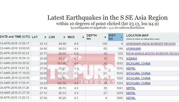
Data from Global Seismic Monitoring center at USA showing 6.9 richter scale magnitude earthquake took place 135 km below earth surface at Myanmar-India Border on 13 April 2016 13:55 UTC which is India time 7:25 PM (19:25)
Eight cities, including Delhi, fall in the “severe intensity zone” or zone IV, according to a seismic zoning map issued by the Bureau of Indian Standards and quoted in a National Disaster Management (NDM) report. The other 30 cities fall in the “moderate intensity zone”, or zone III.
“India has highly populous cities, including the national capital of New Delhi, located in zones of high seismic risk,” said the report. “Typically, the majority of the constructions in these cities are not earthquake resistant. Thus any earthquake striking in one of these cities would turn into a major disaster.”
The Nepal earthquake, which has claimed more than 4,000 lives, and the NDM data are a reminder of India’s vulnerability.
About 50 million years ago, India — then an island that had previously broken off from a supercontinent called Gondwana, a name still used for what is now Chhattisgarh — slammed into the Eurasian mainland, creating the Himalayas as it collided.
All land on earth rides on “plates”, which glide on the mantle, a rocky inner layer. The Indian plate continues to grind into the Eurasian plate, and as it does, the Himalayas and north India are on shaky ground.
Vulnerable zones are monitored, but prediction is impossible
An array of sensors in India and abroad monitor plate activity, but it is impossible to predict an earthquake, as many tweets and Whatsapp messages after the Nepal temblor appeared to indicate
What is available is data on areas of specific vulnerability.
Gujarat and Uttar Pradesh appear to be the most vulnerable states, with six cities each in earthquake-prone zones. Both the states have one city each under zone IV and five cities marked under zone III. Maharashtra is next with four cities in zone III.
The Bureau of Indian Standards (IS-1893 – part – 1: 2002), based on scientific inputs from a number of agencies, including earthquake data supplied by Indian Meteorological Department (IMD), has grouped India into four seismic zones, II, III, IV and V.
The Modified Mercalli (MM) intensity scale, which measures the impact of earthquakes on the surface of the earth, is broadly associated with India’s earthquake zones.
India has 42 digital seismograph stations to measure earthquake magnitude and monitor earthquake activity, operated by the Ministry of Earth Sciences. As many as 78 new digital seismographs are likely to be installed during 2015-16.
- Polling Personnel Hassled during East Tripura Lok Sabha Poll : Video Viral on Social Media
- East Tripura Lok Sabha Poll : Voters boycott votes in Raima Valley, Ampi Nagar
- Two more Arrested in Amit Acharjee murder case
- Railway Police arrested 5 with Phensedyl
- ‘BJP has given chance to Pradyot to correct himself but how dare he attacks me personally ?’ asked Tripura BJP Vice President Patal Kanya Jamatia
Special Articles
 Sanjay Majumder
 Anirban Mitra