TIWN

AGARTALA / DHAKA / NEW DELHI, April 14 (TIWN): Tripura Govt’s disaster management preparedness yet to learn dealing with massive natural disasters like 6.9 magnitude earthquake of wednesday evening. On top of that Tripura is facing major problem with ruling party backed corruptions in AMC (Agartala Municipal Corp) which in turn allowing illegal multistoried buildings like Rose Valley Chit Fund Agartala office. People in Tripura cities Agartala, Udaipur, Dharmanagar, Myanmar's main city, Yangon, in other cities Dhaka, Kolkata, Delhi fled buildings in panic when the tremor struck at 7.25 pm Indian local time. This earthquake occurred at intermediate depth of 135 km, according to the USGS, which means it took place within the Indian tectonic plate as it subducts beneath EurasiaThere were no immediate reports of injuries or damage.The magnitude-6.9 quake struck at a depth of 135 kilometers (84 miles), 396 kilometers (246 miles) north of Myanmar’s capital, Naypyidaw, according to the U.S. Geological Survey. Horrified people across Tripura ran out of homes, hospitals, shops to escape wrath of earthquake. Railway stations, Udaipur's Jagannath Temple reported structural damage, no causalities reported.
North East India is seismically one of the six most active regions of the World, the other five being Mexico, Taiwan, California, Japan and Turkey.
.A strong earthquake struck Myanmar on Wednesday night and was felt in parts of eastern India and Bangladesh.
In the past there were at least 17 major earthquakes with more than magnitude 7 during the period from 1869 to 1988.
Study of the Northeastern Indian’s earthquakes history and findings of seismological researches, the region is now due for a large major earthquake, which is expected in the region between the epicentre of Shillong earthquake, magnitude 8.7 of 1897 and Patkai Range & Arunachal Pradesh , Magnitude 7 of 1950 in the near future.
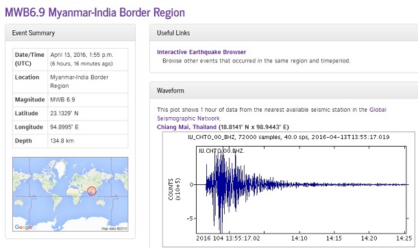
Data from Global Seismic Monitoring center (USGS) at USA showing 6.9 richter scale magnitude earthquake took place 135 km below earth surface at Myanmar-India Border on 13 April 2016 13:55 UTC which is India time 7:25 PM (19:25)
Earthquake hazards of North East India cannot be changed, however disaster can be mitigated.
Major devastating Earthquakes in the North Eastern Region In Past
|
Place |
Year |
Magnitude |
Remarks |
|
Cachar |
March 21, 1869 |
7.8 |
Numerous earth fissures and craters |
|
Shillong Plateau |
June 12,1891 |
8.7 |
About 1542 people died |
|
Sibasagar |
August 31,1906 |
7.0 |
Property Damage |
|
Myanmar |
December 12, 1908 |
7.5 |
Property Damage |
|
Srimangal |
July 8, 1918 |
7.6 |
4500 km2 area suffered damage |
|
SW Assam |
September 9, 1923 |
7.1 |
Property Damage |
|
Dhubri |
July 2,1930 |
7.1 |
Railway lines, culverts and bridges cracked |
|
Assam |
January 27, 1931 |
7.6 |
Destruction of Property |
|
Nagaland |
August 14,1932 |
7.0 |
Destruction of Property |
|
N.E.Assam |
October 23,1943 |
7.2 |
Destruction of Property |
|
Arunachal |
July7,1947 |
7.5 |
Destruction of Property |
|
Upper Assam |
August 15,1950 |
8.7 |
About 1520 people died, one of the biggest known quake in the history. |
|
Patkai Range, Arunachal |
August 15, 1950 |
7.0 |
Property damaged |
|
Manipur Burma Border |
March 21, 1954 |
7.4 |
Property Damaged |
|
Darjeeling |
1959 |
7.5 |
Property damaged |
|
Indo Myanmar Border |
August 6, 1988 |
7.5 |
No casualty reported |
|
Sikkim |
September 18,2011 |
6.9 |
Destruction of Property, loss of lives, 67 dead. |
High intensity earthquake measuring 6.9 on the Richter scale that hit the Myanmar-India border region shook several parts of northeastern India, as also West Bengal, Bihar, Jharkhand and even Delhi and the National Capital Region (NCR). Many people were injured in Tripura, Manipur,Bengal officials said.
The quake was felt at 7.25 p.m. and occured at a depth of 135 km below the earth's surface. It snapped communication -- mobile and landline connectivity -- for a while in some parts and caused damage to some buildings in cities like Guwahati in Assam.
People busy shopping for the Bengali New Year at Agartala, Kolkata ran out to the streets, driven by fear and panic even as multi-storeyed buildings emptied out quickly as residents rushed down to the streets.
The Kolkata Metro Railway services were temporarily halted.
At least 50 people suffered minor injuries in north Bengal. While some of them fell on the stairs in their mad rush to come out of buildings, a few others tripped while running on the streets.
Four-five people were injured in the north Bengal town of Siliguri in Darjeeling district. At least seven others sustained injuries in nearby Jalpaiguri district.
Some of the injured were taken to hospital in Siliguri and sent home after first aid.
At least six people were injured in Manipur when the earthquake shook the state, officials said. The injured were rushed to hospitals, but are said to be out of danger. Hospital sources said their condition was stable.
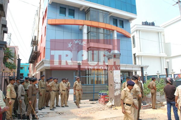
Illegal construction of Rose Valley Chit Fund building, Agartala with active backing of CPI-M Govt. TIWN File Photo
The head offices of the State Bank of India and BSNL in Imphal suffered some damage. The new secretariat as well as the police station buildings in Lamphel area were also partially damaged.
The US Geological Survey put the magnitude on the Richter scale at 6.9 and said the epicentre lay 74 km southeast of Mawlaik in Myanmar.
In Patna, hundreds of people rushed out of their houses and gathered in open spaces. In April last year, a massive earthquake rocked major parts of Bihar, in which 19 people were killed. The epicentre of that earthquake measuring 7.3 on the Richter scale was in Kodari, Nepal.
Tremors shook Assam's main city Guwahati and adjoining areas causing minor damage to some high-rise buildings while the Assam State Disaster Management Authority said no major damage had been reported so far.
The northeastern states -- Assam, Meghalaya, Mizoram, Tripura, Nagaland, Arunachal Pradesh and Manipur -- are considered by seismologists as the sixth major earthquake-prone belt in the world.
Chief Minister Manik Sarkar led state administration yet to issue press release mentioning damages in eight districts of state.
- Absconding Saddam Hussain Arrested by Tripura Police in Yaba Tablet Seizure Case
- Mentally Challenged Woman Was Allegedly Raped: Elderly Man Arrested in Agartala
- ‘BJP has Turned Around to a Great Position in ADC’: Sushanta
- ‘Tripura Has No Oil Shortages’ : Govt Warns Against Fuel Black Marketing
- TSF Burnt CM Manik Saha’s Photo As He Opposed Roman Script for Kokborok Language
Special Articles
 Sanjay Majumder
 Anirban Mitra